Tampilkan postingan dengan label Tourism. Tampilkan semua postingan
Tourism Objects of Central Sulawesi Province
Central Sulawesi Province
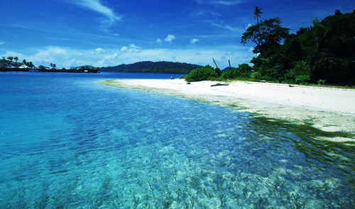
Central Sulawesi Province is beautiful region with its mountain; lakes and dales decorate this area. All the things are tourism potency that becomes a fascination for tourist to visit it. The fascination of main tourism in Central Sulawesi is megalith omission area of historic epoch, which stay in Bada and Besoa, however the natural beauty and sociability of its public become valuable asset for the tourism expansion in this area. Central Sulawesi is one of regional in Indonesia that has compatible solidarity between natural beauties, cultural properties and long history.
GOVERNMENT ADMINISTRATION AREA
With the Government system development and people demand in Reformation era who wish the spin-offs of the region become regency, hence the Central government release policy through the constitution number 11 in 2000 about the change of the constitution number 51 in 1999 about the forming of Buol regency, Morowali regency and Banggai Island. Then through the constitution number 10 in 2002 by Central government had formed new regency in Central Sulawesi Province named Parigi Moutong regency. Thereby finite, based on the spin-offs of regency area in Central Sulawesi Propinsi, Become nine region named:
- Donggala Regency in Donggala
- Poso Regency in Poso
- Banggai Regency in Luwuk
- Toli-toli Regency in Toli-toli
- Palu city domicile in Palu
- Buol Regency in Buol
- Morowali Regency in Kolonodale
- Banggai Archipelago Regency in Banggai
- Parigi Moutong Regency in Parigi
GEOGRAPHICALLY
Central Sulawesi Province being formed with the constitution number 13 in 1964 laying between 2022' North Latitude and 3048' South Latitude and 119022' East Longitudes. Its region Boundaries is:
North side: Gorontalo Province
Eastside: Maluku Province
Side South: South Sulawesi Province and South-East Sulawesi Province.
Westside: Makassar Strait
North side: Gorontalo Province
Eastside: Maluku Province
Side South: South Sulawesi Province and South-East Sulawesi Province.
Westside: Makassar Strait
DEMOGRAPHY
The area wide of Central Sulawesi Province is 68033 Km2. Administratively, Central Sulawesi Province divided into eight regencies and one town with 85 Districts dan1432 village with number of residents' 2.215.449 men and density of average level is 29 men/Km2. While the resident growth rate equal to 2,59%. While the resident of Central Sulawesi Province who resided in settlement area of hinterland is 30% coastal area is 60% and archipelago area is 10%.
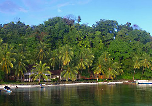
Tourism Objects of Central Sulawesi Province
Poso
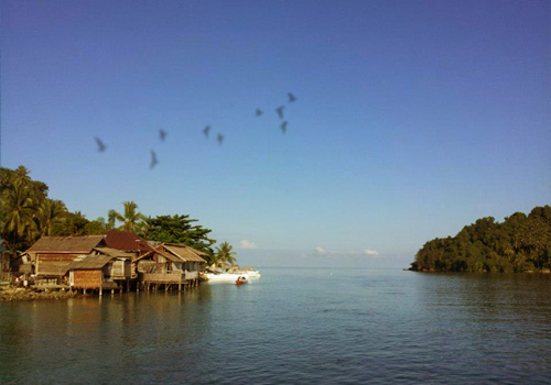
Poso is the city main port and port town and terminal in north coast Central Sulawesi region. For tourist, Poso is sojourn town (transit) before continue the journey to some tourism locations around Poso for example to the beach or to Ampana for then join with others ship towards to Togean Island. However, Poso self is pleasing town for a take a rest before continue the journey.
Poso is a regular small town, and you can go wherever you want in this town only by feet. Poso Downtown located in Sumatera Street and the around area which has a number of hotels, restaurant and shop area.
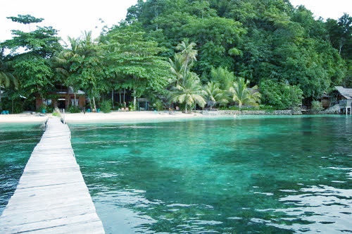
Around Poso
There are some interesting locations to visit around Poso especially for they who like to swim or snorkeling; one of them is Madale Beach, which is located about 5 Km in east Poso. Farther easterly, at 20 Km from Poso, there is Matako Beach with the white shore sand, While, Toini Beach is located about 7 Km from Poso to west. This beach is very popular because there are a number of restaurants that present delicious sea dish. This third beach can reach with public vehicle (machinery trishaw) from terminal near to market Poso.
About 40 Km from Poso eastwards there is Tombiano that have big cave that dwelt of bat; in Maranda which is located about 47 West km Poso there is cascade as well as source of hot wellspring where visitor can swim; Tampenaporo Cave located in 22 Km in south Poso, in road towards to Tentena. For visit this location of the cave and waterfall you can join with others common vehicle from terminal Poso to appropriate purpose, and ask the driver to reduce you in location that being gone.
Lembomawo located about 4 Km in south Poso and known as crafting center of woodcarving ebony. To reach this place you can join with others machinery trishaw from terminal Poso and downwards in Lembomawo. From Lembomawo you can walk (4 Km) to Ranononucu through two drawbridges. Here there are a lot of shops that sell ebony.
Poso Lake

The third biggest lake in Indonesia has the wide about 32300 hectares with about 450 meters depth. Poso Lake has 32 Km length and wide 16 Km. The Lake situation is reside in 600 meters height above sea level make this area air is nocturnal balmy without have too cool. Visit Poso Lake to become the main reason people to halting-place in Tentena and Pendopo, which is each, located in north back part and south of Poso Lake. Both this places are attributed to supporting facilities for crossing regular transportation lake. Tourist can walk along to fringe rural area around lake or rent boat to encircle lake. Poso Lake also famous because it have orchid garden called Bancea Orchid Garden that has wild orchid collection. This garden can reach by walking (11 Km) or join with others rental car to Taipa from Pendolo.
The tourism location Salopa Waterfall reside in a forest area near to Tentena, there are a number of rapids, waterfall and some pools with the transparent water as clear crystal.
Sulewana Waterfall
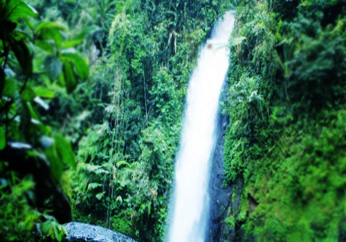
Sulewana Waterfall located 10 Km from Tentena. To reach this place you can join with others machinery trishaw, which towards to north and continued by walking of 3 Km in each August month is, performed an event named Poso Lake Festival which is the biggest event culture in this region. This festival followed by the village public who reside in this beautiful area. Pendolo, which located in tip of south and resides in Poso Lake periphery, is silent village.
Lore Lindu National Park
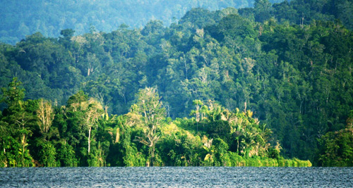
This national park cover 250,000 hectares width area and rich multifariously exotic crop and various animal types and insect, include the butterfly that larger of human hand. National garden area also become the original society place with their custom clothes they gorgeous and usually used at execution of traditional event. The other fascination in this national park is the objects (relict) that made by the historic man from megalith epoch that had dwelt this region for thousands year ago. A number of relicts can be met in Bada dale, Besoa and Napu.
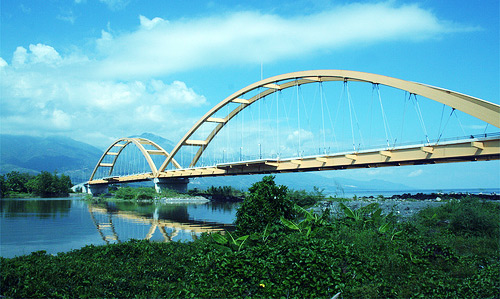
Tentena

Tentena which located in back part of north Poso Lake is the wider village and more beautifully from Pendolo. This place encircled of hilly that grew by clove crop. When bloomy clove (finite June to November), clove tree will release clove interest fragrance. Tentena have accommodations facility and complete restaurants, but the beach in Tentena still beautiful compared to in Pendolo. The interesting location, which must be visited when you to reside in Tentena is bridge along 210 meters length that reside in back part to be north Poso Lake. Under the bridge, lake water rapidly flows to enter river to start the length journey towards to sea.
Tentena is famous with eel animal with length reach two meters. These animals live in lake base and a lot to exit follow the water current towards river. In the riparian there is Pamona Cave. Panorama near to this cave is enough beautirfull. Farther to the town, in roadway towards to Kolonodale there is Latea cave that contain of dead body bones that buried during in the past.
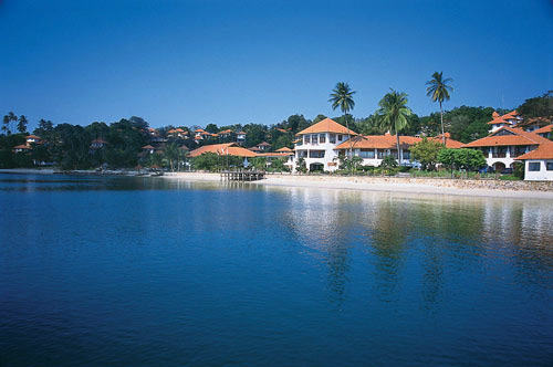
Palu
Palu is the capital Central Sulawesi Province, which geographically this region located in upstate. Town which seldom has rain known as one of dry town in Indonesia with hot air in the afternoon and nocturnal cold. In it history, Palu has ever occupied by Japan army in world second. In general, the tourist visit Palu because wishing trekking to Lore Hindu National Park that reside in south Palu or Tanjung Karang that is reside in north.
If reside in Palu it is possible you can visit Central Sulawesi Province Museum that have collection of folk art objects as well as archaeological object. You also can visit traditional house Banua Souraja and Datu Karama. Palu Beach is the cleanness beach.
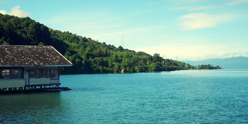
Kolonodale
This small town located in one of Tomori Bay angle with the beautiful panorama. Kolonodale is the gateway towards Morowali Garden, which is preserve area. This area has level of height rainfall and takes place approximant during the year. The best time to visit this place is during September and November. Most of lodging, shop and market reside in located area not far from the main dock. The intersecting street in front of market is also functioned as bus terminal.
Tomiri bay
Most of the tourist who reside in Kolonodale would be towards to Morowali and don't exploit the opportunity to look beautiful panorama around Tomori Bay. Around Tomori Bay area there is small bays with rocks ashore meeting with clear seawater. Bay area to be encircled by hilly that closed over the forest; so also in water territory around outspread bay small islands which in the centered is grew by the forest which still be original and in its periphery is outspread is beautiful coast. All the things unite to to become impressing natural beauty.
Along the Kolonodale Beach, there is reef that have fossil and hand image of historic man that sticking on the stone. Also there is reef, which is in mushroom form. To enjoy all of this beauty optimally, hence tourist need to rent speed boat from Kolonodale with tariff about Rp 100000 per day.
Donggala
During colonial, Donggala is port town and commerce that is enough busy in Central Sulawesi region. But when Donggala port had superficiality, hence trade ships that were usually halting-place to this place, move to other port. Now on, Donggala position for tourist, is only as transit town before towards to 'Tanjung Karang', which is the important tourism location in this region.
Karang Foreland
Karang Foreland is located about 5 Km in north of Donggala is coastal area with the shore sand and sea is a real please for water activities like swimming and snorkeling. The tourists who come to this place are they who fond with shore sand, seawater and sunshine. This tourism object location has sufficient accommodation facility and most of lodging in this place has rent the snorkeling equipments.
Togean Archipelago
Foreign tourist, who is visit Togean archipelago for the first time, will feel fall in love with its rock islands beauty in this place. The beauties of Togean nature make many tourists finally choose to remain longer from initially plan. Archipelago that is located in the middle of Tomini Bat is grew by forest area, which have not touched and become shelter for the animals in it. But the real beauty resides in the beach and sea. Various combinations forms of rock unite bluely of clear seawater make the beauty of this place become hardly impressing.
Togean Archipelago is the only place in Indonesia that has three different rock areas but stay in one same area. The three rock areas is atoll rock, barrier rock and coastal rock, all become flora and sea fauna habitat. Atoll rock is coral island form that midst of its there is deep lake. Barrier rock is in a row consecutive rock encircle the island look like fortress or wall on the sea that protect other island in nearness from the sea wave dashing against. This rock height start from finite base to sea level reach 200 meters, this is not including part of rock on the surface, which able to reach some meters height, again.
Togean Island
The main settlement area in Togean Island is Katupat village that have a small market and a number of shops. Around island there is coast area, which more beautiful from other place and jugs location for trekking for tourist who have been be fed up with activity dive, swim, or snorkeling. This place is also available of lodging, for example Melati Motel, Fadhila Cottages and Bolilanga Indah Motel.
Batu Daka Island
Batu Daka Island is the biggest island and easiest to reached in Togean archipelago. In Batu Daka Island there are two villages that is Bomba and Wakai. Bomba village, they are the settlement area, which located in northwest back part of Togean archipelago. Bomba is the most beautiful place in Togean area and not crowded, hence most tourists' pass this place is just for towards main purpose that is to Wakai in Kadidiri Island.
However Bomba is interesting place. Here, the visitor can swim and snorkeling in good location. You also can visit bat cave, which located near to Bomba but to visit this place required by guide.
Wakai
The biggest settlement area in Togean is Wakai. This place is point of departure for ships, which would towards to Kadidiri Island. In this place there are two lodgings and a number of haberdashery shops. Some kilometers towards hinterland there is waterfall. Tourist can do the pleasing journey towards to waterfall through the villages, which stay in this area. Two lodgings in this place are Wakai Cottages and Togian Island Hotel.
Kadidiri Island
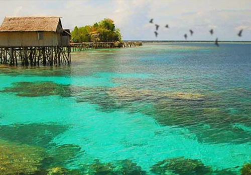
Kadidiri Island, which is located not far from Wakai, is the center of tourism area in Togean Island. Kadidiri Island is very popular island among tourist because the beach is a real good with snorkeling location and dive a real prima and it also available many doss houses. In Westside of the coastal there is consecutive precipitous reef that become rock crab habitat.
Malenge Island
Malenge Island is island, which rather cloistered but has a real good water territory area for snorkeling with the location not far from the beach. The local resident with NGO help have built the journey route to pass is ambient forest and mangrove forest which good for assisting to know the places or animal habitat in this island like monkey, hornbill, polecat and salamanders. Lodging in this island can be met at near to dock for example Malenge Indah Motel, Lestari Motel and Honeymoon Beach Bungalows.
Walea Kodi Island
The only settlement in Walea Kodi Island is in Dolong village, which is fisherman village that is enough stirred. The tourism facility and transportation in this place are very limited. Dolong, have coast that is not too good but there are a number of locations to snorkeling. The lodging in this place is Lima Hotel and Walea Dive Center Resort.
Banggai Archipelago
This archipelago is a real good area to do various activities of water like swimming and dive. In this water territory area the tourist are possibly to see dugong or sea cow and even whale. Although its panorama is very good but the accommodation facility in this island still limited but the tourist admit of lodge in houses property of resident after ask permission to local village head. The tourist can rent speedboat, which can be met in every village if we like to encircle this archipelago area.
50 Interesting Facts About Indonesia (Part II)

11. Indonesian badminton team is the most won badminton men symbol of supremacy, Thomas Cup, which is about 13 x (the first time last yr 1958 & 2002). But China's risky to be exceeded, see this recent trend.
12. Indonesia is a producer of liquefied natural gas (LNG) in the world (20% of world supply) is also the second largest tin producer.
13. This country has natural gas reserves LARGEST IN THE WORLD! precisely in the Natuna. How much gas content in the Natuna block? Natuna D-Alpha gas reserves of up to 202 TRILLION cubic feet !! and many of Block-Block mines and oil as Cepu etc. Who managed? Exxon Mobil! assisted at Pertamina.
14. This country has the largest tropical forest in the world. This tropical forest has total area 39,549,447 hectares, with biodiversity and plasmanutfah comprehensive in the world. It is on the island of Sumatra, Kalimantan and Sulawesi. Actually, if this country wants the apocalypse is very easy for them. Cutting all the trees in the forest, the earth certainly doom. Because the earth is very dependent once with this tropical forests to maintain the balance of the Amazon rainforest climate because not strong enough to balance the Earth's climate and now they gradually sediki have mengkancurkanya only to a handful of people who have money to estate and golf course. How ironic.
15. Indonesia ranks first in agricultural products, namely: Clove and Nutmeg, and No. 2 in the natural rubber and crude palm oil.
16. Indonesia is the largest exporter of plywood (plywood), which is about 80% in the world market.
17. Coral Reef (Coral Reef) Indonesia is the richest (18% of the world total).
18. Indonesia has the most shark species are 150 species.
19. Biodiversity Orchid terbeser world: 6 thousand species of orchids, ranging from the largest (or Grammatophyllum speciosum Tiger Orchid) to the smallest (Taeniophyllum, with no leaves), including a rare black orchid and only in Papua.
20. Has the largest mangrove forest in the world. This plant is useful to prevent sea water erosion / abrasion.


Tourism Objects of Riau Archipelago
RIAU ARCHIPELAGO

Its waters are the backyard of native seafaring nomads who fish and trade for a living. Their traditional wooden sailing craft, called 'pinisi' still do the forested channels of these islands, along with other indigenous craft, fishing vessels and cargo ships which call at the archipelago's main town and Tanjung Pinang port. Tanjung Pinang lies on the largest island of Bintan archipelago. Once known as Riau, it was the heart of an ancient Malay kingdom. Today, Bintan is the latest hot spot of development in Indonesia's surging economy.
A master plan is underway to turn it into a major tourist destination. Barely an hour away from Singapore by ferry, tourist accommodation has begun to appear to take advantage of its gateway from it all appeal. It consists of Riau Archipelago, Natuna Islands and Anambas Archipelago. Originally part of Riau Province, Riau Archipelago was split off as a separate Province in July 2004 with Tanjung Pinang as its capital. Anambas Archipelago, located between mainland Malaysia and Borneo were attached to the new province. By population, the most important Riau islands are Bintan, Batam and Karimun. Size wise, however, the sparsely populated Natuna Islands are larger.
Riau Archipelago with its thousands of island has plenty of scenic beaches and diving spots, among them Trikora on Bintan and Pasir Panjang on Rupat Island. The first is about 50 kilometers south of Tanjung Pinang on the eastern side of the island. Pasir Panjang, on the northern side of Rupat facing to Malacca Strait, is stretched out natural beaches are also found on Terkulai and Soreh islands, about an hour's distance by boat from Tanjung Pinang. One of the most popular beaches is Nongsa on Batam Island. From here one can see the Singapore skyline.
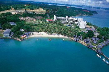
GENERAL INFORMATION OF BATAM ISLAND
Batam is one of the 3,000 islands, which make up the Riau Archipelago and is closest to Singapore, which is only 20 km away or twenty minutes by air-conditioned ferry. It has a rapid-growing population of around 100.000. As the island develops into a major industrial and tourist area, it attracts an ever-increasing population from other Indonesian islands who see Batam as a haven of opportunity. Once almost uninhabited, save for a few scattered fishing communities, Batam's history took a sharp turn beginning 1969, when it became support base for the State-owned 'Pertamina oil company' and its offshore oil exploration. In 1971 a presidential decree designated it as an industrial area and in 1975 the Batam Authority was formed. In 1978 Batam was established as a bonded area.
In addition to the oil support industries of Batu Ampar and a fast growing electronics industry, Batam now attracts increasing numbers of tourists. Many come from Singapore for a short holiday with friends and family, duty-free shopping and great seafood. The visitors to Singapore hope over for a day or weekend trip.
International standard hotels and numerous economy establishments cater to the expanding demand for accommodation. Business, as they say, is booming. An island two-thirds the size of Singapore, Batam progresses by leaps and bounds. Where virgin jungle once stood are now whole new towns, mosques, churches, temples and supermarkets, soon to be followed by reservoirs with enough water to supply a population of 800,000 and for industrial use, an airport-to become an international gateway - a fine telecommunication system, well equipped industrial parks, and the beginnings of a large new urban center.
Administratively, Batam enjoys a unique status under the Batam Island Development Authority (BIDA). The island is duty-free. The holiday market, this means duty free shopping in town, hotel shops and the ferry terminal. For the businessmen it means wide-ranging opportunities for investments. While all this change takes place, Batam has retained pockets of rural charm, peaceful spots with quiet beaches. Fishing villages supply delicious fresh seafood to visitors. White sand beaches are fringed with palms and kampung life carries on almost undisturbed. Batam makes a great break.
One of Batam's biggest attractions is the fresh and delicious seafood. Giant prawns, live still crawling crabs, live fish taken straight from nets in the sea, lobsters, clams and shellfish are cooked in a variety of styles and all delicious. Try the local 'gong-gong' conch shell where the succulent meat inside is fished out with a pin and dipped in a spicy sauce before eating.
GENERAL INFORMATION OF BINTAN ISLAND

Bintan is the largest island in the Riau province, with its area is 1.140 sq. km width, with a coastline of about 105 km. The island has a population of about 200.000, and like the rest of Riau this is a true mix of cultures like Malay, Bugis, Chinese and the Orang Laut. Bintan is very close to the equator and have a tropical climate throughout the year, with temperatures ranging from 21° to 32°, with an average of 26° Celsius.
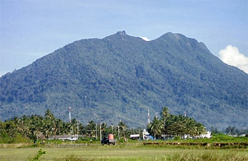
Bintan and Batam saw before the economic crisis huge investments and development, including industrial parks and large tourist resorts. Bintan has since become a popular tourist destination due to its close vicinity to Singapore. Here we can get accommodation of all standards, and it is still possible to find a peaceful spot on Bintan far from other tourists. Most of the tourism is concentrated on the north coast around Lagoi, while the east coast is still unspoiled and worth a visit. In a not so distant past Bintan was completely covered with tropical rain forest. This is now all gone, except a small forest that covers the highest mountain on the island, Bintan Besar. The mountain is the remains of an old volcano, and has an elevation of 376 m, the highest point on the Riau islands.
In Bintan, diving promises to be comfortably civilized, with all underwater needs catered to Mana Mana Beach Club - Bintan Resort's professional water sports center. Out of the water, Bintan will be the place with something for everyone. There's the golf course, horses for riding and jungles for trekking - alternatives aplenty to tempt hardened divers to stay topside.
ANAMBAS ARCHIPELAGO

Anambas is a group of islands midway between Singapore and Natuna Besar. The main islands are Matak, now a base for oil exploration, Tarempah and Jemaja Andriabu. The population is sparse, mainly simple fishing folk that are the descendants of the once mighty Bugis people. The main source of income is from sea products and coconuts. The islands has become a popular destination for divers from Singapore, the best known sites are the underwater reef systems of Tokong Malangbiru island, the submerged Acasta Rock, the disused Udang Oil Rigs and the wrecks of the sunken vessels "Seven Skies" and "Sara-D". The closest sites can be reached in a half-day's boat ride from Singapore, while the Udang Oil Rig to the northeast is about one and a half day away. Tours with boats where we can live onboard are arranged from Singapore. The other islands of Anambas archipelago are Tarempah and Jemaja Andriabu.
Tarempah Island is a tiny town with only one scruffy and small guesthouse; we can hire a local fishing boat here for a reasonable price and explore the surrounding area. Tarempah Island was probably the first Dutch territory attacked by the Japanese during WW2. The Tarempah village was heavily bombarded and most of it destroyed, 40 civilians were killed and 100 wounded, the remaining villagers were evacuated to Tanjung Pinang on Bintan. Anambas were occupied by Japanese troops on 26th of January 1942 and used as an advanced naval base, the rest of Natuna were probably occupied shortly afterwards.
NATUNA ARCHIPELAGO
The Natuna Islands are a 272-island archipelago of Indonesia, located in the Natuna Sea between east and west Malaysia and Kalimantan. The islands are officially part of the Riau Archipelago Province. Natuna is one of the northernmost island groups of Indonesia. The main islands of Natuna Archipelago are Natuna, South Natuna and Tambelan. The South Natuna group comprises the islands of Serasan, Panjang and Subi. The Anambas archipelago, located several hundred kilometers to the west and comprising Terempa, Matak and Jemaja Andriabu Island, are also sometimes included in the Natuna Islands.
Natuna can however offer unspoiled beaches and a landscape and a culture that is absolutely worth a visit. The islands are known for lovely woven textiles and their traditional dance. The Natuna islands are spread over a wide area, located in the South China Sea between east and west Malaysia, Kalimantan and Singapore. The main groups of islands are Anambas to the west, Natuna, south Natuna and Tambelan. One of the largest natural gas fields in the world has been found here, The Natuna gas field in the North and South Natuna archipelago is believed to have 222 trillion cubic feet of natural gas in reserve, 46 trillion of this can be recovered. In the future the Natuna Natural Gas Project will be very important for Indonesia's economy.
Ecology
The Natuna Islands have a remarkable avifauna with 71 species of bird registered, including the near-threatened Lesser Fish-eagle, the Natuna Serpent-eagle or the rare endemic Silvery Wood-Pigeon. Among other species endangered species, we find the Green Iora, the Brown Fulvetta or the Green Broadbill.
Natuna Besar
Natuna Besar (or Ranai) is the largest and northernmost of the islands and also one of the northernmost points in Indonesia. Here we can find lovely corral reefs and a large variety of fish. The population is relatively small, but some people have been moved here by the government from other islands in Indonesia and grow products like peanuts and peas. Mount Ranai, the highest mountain in Natuna archipelago at 1.035 m, is located on this island. There are some great areas for diving here, the waters of the South China Sea around the island can offer an unique underwater world, the coral is normally found within five to ten meters below sea level and 50 to 750 meters from the shore. Smaller islands like Senoa to the northeast can also offer white beaches and coral reefs, Panjang to the northwest is known for the protected green turtle, and can be reached by boat from Natuna Besar in 30 minutes. Totally there are about 20 small islands surrounding Natuna Besar.
South Natuna
South Natuna is located between Natuna Besar and the Kalimantan mainland, the main islands here are Serasan, Panjang and Subi. The islands have a strong surf and impressive scenery.
KARIMUN ISLAND
Karimun is one of the most important islands in Riau Archipelago, due to its thriving economy and proximity to Singapore. Tanjung Balai Karimun is a medium-sized town, with a large Chinese community and shops selling a large variety of imported items. The town is linked by both sea and air. Terkulai and Soreh are resort islands nearby which are popular with holidaymakers.
History
Karimun regency in the beginning was a small town with the name of Tanjung Balai Karimun and with its status as a sub district town with the area of only 275 sq km. Tanjung Balai Karimun, from the scope of history, cannot be separated from its main regency that is Riau islands. Based on the decree of delegation of the Republic of Indonesia, the province of central Sumatra on may 18, 1956 joined the republic of Indonesia, and Riau island were given the status as level II autonomy region which is led by a regent as head of the region who supervised 4 (four) districts, that are:
- Tanjung Pinang District, which covered sub district of South Bintan (incoming East Bintan, Galang, West Tanjung Pinang and East Tanjung Pinang now).
- Karimun District which covered sub district of Karimun, Kundur and Moro.
- Lingga District which covered sub district of Lingga, Singkep and Senayang.
- Tujuh Island District which covered sub district of Jemaja, Siantan, Midai, Serasan, Tambelan, West Bunguran and East Bunguran.
Karimun district, later were abolished based on the decree of governor, head of the level I region of Riau dated August 9, 1964 no. Up/247/5/1965. Based on such stipulation, as of January 1, 1966, all administrative territory of the district in the Riau Islands regency was abolished. It is written the history that in glory of Riau Lingga kingdom when it took over the famous Johor kingdom, most parts of Riau islands territory were in the authority of kingdom of Riau Lingga. It is mentioned that the glorious time of Riau can be depicted by the incoming flow of international commerce since there were so many foreign traders lived in Bandar Riau. Furthermore, it was explained also about the prosperity of this Riau territory, especially at the time his young majesty King Ali held the power. Riau had experienced rapid development. Such historical meanings had implicated the economic situation in this territory nowadays.
Along with the spirit of regional autonomy, then on October 12 law no. 53, 1999 was stipulated which stated that Karimun regency together with kundur and moro regency were merged to one regency with the name of Karimun regency, with position at the same level with other regencies in Indonesia.
Batam Island Tourism Objects
Sekupang
At present, Batam's main entry point is Sekupang, where streamlined fast and air-conditioned ferries bring hordes of quests from Singapore and Malaysia. The twenty-minute voyage is enlivened with free cool drink and video show, although some prefer to stand on the top deck and watch the sights. Ferries shuttle daily every half-hour between Singapore's Finger Pier and Sekupang harbor, and during peak period, even more frequently. For travelers' convenience, there are hotel, taxi and ferry counters at the ferry terminal. Within walking distance from the terminal is Batam authority office. Further down the road overlooking Sekupang harbor is Wisma Batam where we can see, upon request, an audiovisual presentation on Batam's development up to 2005. Batam's two popular FM stations, the Batam Zoo 1101.6 and Coast 100 are in the vicinity. Looking over the whole Sekupang and the hilly interior is the Hilltop Hotel. Popular with long-staying guests as well as tourists, this hotel is to be expanded and upgraded to new heights. Its restaurant serves fine Indonesian food and western specialties. In Sekupang try the Indonesian Delights, where regional Indonesian dishes are offered to the accompaniment of traditional dances.
Nongsa
Batam's northern coastal area of Nongsa, an hour's drive from Sekupang, is the main tourist attraction, where the resorts and golf courses are situated. Batams has best known; the Batam View and the beautiful Turi Beach Resort take pride of place as does the nine-hole Talvas Golf and Country Club. Besides catering to tourists, these hotels are also popular for small conferences. At the end of the promontory is the small Nongsa River, which is to be preserved in its natural state. Hotel guests can take boat trips up the river and perhaps see birds and wild Monkeys, or take in the solitude of the quiet waterways. En route to the airport, just south of Nongsa is Batu Besar, a cluster of restaurants offering fresh seafood. Built on stilts out over the water, guests are assured of a cool sea breeze while dining, and drinking ice-cold beer or the cool juice from a large green coconut.
Nagoya (Lubuk Baja)
Nagoya is located halfway between Nongsa and Sekupang. Lubuk Baja, or popularly known as Nagoya is Batam's colorful and fast growing heart. Shops, stalls, footstools, nightlife, discos, music lounges, karaoke, restaurants and many small hotels make this busy community popular with the locals and the businessmen alike. Hunt here for bargains and Indonesian goodies. For a good time, Nagoya is the spot. Until the Batam Center is established, Lubuk Baja is Batams present center of business, trade and finance. Nagoya is Batam's entertainment center. While resorts offer there is own brand of quiet evening music, Nagoya is definitely the place to go for nightlife. Bars are plentiful and disco lively. Shinta Nightclub has overseas cabaret acts and the Regina Palace is one of the favorite nightspots. Tired folk can enjoy a relaxing and stimulating massage in one of the many salons In Nagoya. Karaoke Lounges are big news, where guests can live out their singing talents in congenial surroundings.
In Batam, finding fresh seafood is no problem. Anyway that visitors find their way to, a seafood restaurant will have preceded them. Nagoya has many restaurants such as; Batu Besar, Batu Merah, Telaga Punggur. Late night ferries from Batu Ampar allow diners to eat at a Batam restaurant and return the same evening to Singapore. Genuine Padang food can be found at Pagi Sore restaurant in Nagoya.
Batam Centre

Batam Centre is face to Tering Bay; construction work on the Batam Center has already begun. To be the pride of Batam, the Center is a planned city with business district, hotels, shops and a marina. Indonesia's President Soeharto and Singapore's first Prime Minister Lee Kuan Yew each planted a banyan tree on 29 November 1987, marking the close friendship between the two countries and the beginning of construction on Batam Centre. Later Prime Minister Mahathir of Malaysia to join them planted a tree. The first buildings are almost completed and will soon be joined by international hotels including a Sheraton and a Shangri-La.
Kabil

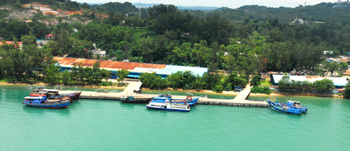
In the southeast of the island, Kabil marks the site of a major deep-water port already under construction. When completed, the Asia Port will accommodate ships of up to 150,000 DTW with a total wharf length of 5,000 meters. Together with its free trade zone status, Asia Port makes an attractive shipping proposition and is already drawing interested responses. Presently, lighter shipping berth at Batu Ampar and Sekupang ports in the north. Speedboats may be hired here for our transfer to neighboring Bintan Island. Nearby, in direct contrast to the heavy industrialization is Telaga Punggur, offering a taste of old Batam. In the midst of a quaint fishing village are several more seafood restaurants, it is easy to while away several delightful hours here, eating and watching the passing parade of sampans and fishing craft as they go about their business.
Hang Nadim

Batam's busy regional airport is in the throes of major construction works. New runways accommodating large carrier planes such as the Jumbo Jet and the Airbus will be ready by 1993, when Batam will become an international gateway to Indonesia by air as it already is by sea. The airport provides connections to many Indonesian cities, including to Jakarta, Pekanbaru, Bandung, Medan and other secondary cities. Garuda Indonesia flies several daily flights to Batam, Sempati, Merpati, SMAC, Deraya and Airfast.
Bintan Island Tourism Objects
Tanjung Pinang

Tanjung Pinang, is the main port town on Bintan Island, where trade and passenger ships link to all parts of Indonesia and Singapore. Bintan is a good point of departure to other islands in the area and only a two-hour boat ride away from Singapore. A large section of the old part of the town was built in traditional local fashion, on stilts, over the water, although today, its face is changing rapidly, with several first-class hotels and yachting marinas being developed. Seafood at the night market is great. Trikora Beach is about 50 kilometers south of Tanjung Pinang on the eastern side of the island. Good beaches are also found on the islands of Terkulai and Soreh, about an hour away by boat.
Tanjung Pinang is a busy little town on Bintan Island, visited by traders from Jakarta, Medan, Palembang and other big cities in Indonesia, Tanjung Pinang is only a two-hour boat ride away from Singapore. The town has a Museum located on Katamso Street. A large section of the old part of the town was built in traditional local fashion, on stilts, over the water. Bintan is a good point of departure to other islands in the area.
The main town on Bintan is Tanjung Pinang, which can be easily reached from Singapore. It is located on the western part of Bintan Bay, and is also the largest town on Riau Archipelago. It has the usual Indonesian chaos, but also its share of charm, especially the stilted buildings that sits above the water in the northern part of town is worth a look. Tanjung Pinang has a busy harbor that is strategically located close to the Malacca strait, one of the world's busiest sea-lanes. Most of the ships arriving Tanjung Pinang are however smaller vessels coming from all over Indonesia and from Singapore.
The 28m tall Raja Haji Fisabillah Monument of Struggle sits in the western part of Tanjung Pinang and is raised in memory of the hero Raja Haji who died during the battle for Malacca against the Dutch in 1784. The Sungai Ular (Snake River) Buddhist Temple is another attraction opposite the harbor in Tanjung Pinang. The visitor can also visit some of many small islands with fishing villages just a few minutes by boats from the town, and of course Penyengat Island. Tanjung Pinang is well known for good and inexpensive seafood and has a large selection of mussels, prawns, fish, squid and gong, a local specialty (shellfish). Also other traditional Riau food is served here, one specialty is "otak otak", fish meat cooked in coconut milk mixed with Indonesian spices and wrapped in coconut leaf, we can also find traditional Nasi Padang rice dishes. There are a large number of shops here, with a variety of relatively cheap goods, including electronics, tools, jewels, toys, batik and gold.
Tanjung Uban

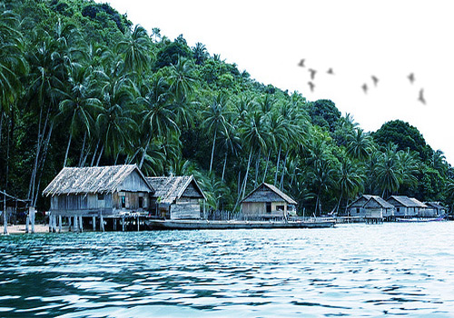
The largest town besides Tanjung Pinang is Tanjung Uban on the north west coast. From here, it is a short distance if we reach it by boat to nearby Batam the ticket is cheap. Tanjung Uban has oil storage and is a district center. Along the sea there is a charming boardwalk called "pelantar" with houses, accommodation and restaurants built over the sea, behind this is the main street with shops.
Trikora Beach

The most popular beach on the east coast is Trikora, where also the locals use to go for relaxation on the holidays. It can be difficult to get there, go by taxi or the occasional bus from Tanjung Pinang. Even if the beach is isolated we can find simple accommodation here, even a more luxurious alternative. The sand is white and the water clean, a great place for relaxation after the hot and busy streets of Tanjung Pinang. We can also visit a fishing village nearby and a small ship building facility to have a look at traditional boat building.
Penyengat Island

Penyengat Island, 6 kilometers away from Tanjung Pinang, can be reached in 15 minutes by sampan boat. The seat of the powerful Bugis descended viceroys of Riau during the 18th century; Penyengat still bears the traces of its illustrious past. Ruins, abandoned for almost 70 years, were recently resorted. The oldest ruler's palace and royal tombs, among them the grave of the book respected Sultan Haji, author of the first Malay language grammar book among the legacies left by the Riau sultanate. A newly built cultural center for stage performances of Malay music and dances can be found.
In the 18th century Raja Haji built an outpost here as part of the defense around Bintan. He controlled the area until the Dutch at Malacca eventually killed him in 1784. His remains are now buried here. The ruler of Johor, Sultan Mahmud, gave the island to his Bugis wife Raja Hamidah in 1804. Raja Hamidah's son then ruled the Riau islands from Penyengat, while his half-brother ruled in the Lingga Island to the south. Raffles turned this division to his advantage in 1819, when the prince of Penyengat gave him the island of Singapore in return for a large sum of money and the protection of the British crown.
Under the protection and support of the British the area saw an "golden age", and the remains of this prosperous time can still be seen on the island. Some of the ruins have recently been restored, like the old ruler's palace and royal tombs. The old mosque, Mesjid Raya, is still in use. A cultural center is also newly built for performances of Malay music and dance. At the west end of the island there is an impressive stone fort, built by Raja Haji to fend off Dutch attacks.
The restored palace of Raja Ali is located in the center of the island. Raja Ali was a strict follower of Islam, things like gambling and cockfighting, the wearing of gold and silk for men and mixing of unmarried men and women were strictly forbidden. His yellow and green Royal Mosque can be seen from far away, completed in 1844 it became an important center for Muslim Malay learning in the 19th century. Penyengat Island actually became the cultural capital of the Malay world, and some 9.000 people inhabited the island, among them religious scholars from as far away as Mecca.
The importance of Penyengat ended when the last Sultan of the Riau-Lingga, Abdul Rahman Muazzan Shah, refused to sign a contract with the Dutch that terminated the rights and authority of the traditional king and officers of Riau. The Dutch then informed him that his palaces, buildings, land, etc, would be confiscated. To prevent this, he ordered Penyengat people to destroy the Dutch possessions on the island, this is the reason why there is not much left on Penyengat that shows its former glory. Today there are about 2.500 people living on the island, about one third of them are descendants of the former royalty, most of the residents make their living of fishing, while some work on the main island.
Because the participation of Penyengat Island was very important in historical of Riau Kingdom, so the island what relatively is very small it is to be well known and attention peoples to visit it. More over at there is still has much kind of historical last sites. At this island beside has much some kind of historical sites; it founded another interest objects like wonderful views, tradition couch, arts attraction, and traditional villages.
Tag :
Tourism


